 |
| Rough "sketch" of new fence location |
So I've been searching around looking for ways to visualize and plan the garden space for the edible landscape. The space needs to be separate from the dog yard so the dogs don't climb through the beds, do their business on the almost ripe veggies, or eat the harvest. After walking around the yard and watching the sun/shade patterns move across the yard, my initial wish to use the area by the existing fig trees still seems the best.
 |
| Edible Landscape Set Aside |
The current plan (and by far the best option thought of to date) is to build 2 sections of 4' chain link (matching existing fence) which will establish a dog free area in the back yard (see top photo). I'm excited about this proposed garden location although it needs some work - the water spigot is not functioning currently and there are overgrown bushes that need attention. However, the space has lots of potential.
I'm using Google's SketchUp 8 (the free version for now) to develop a 3D model of Meadowood Ranch. What about Google SketchUp? In several ways it works similar to a 3D mathematical modeling program I use at work called Environmental Visualization Systems (EVS) by C Tech. As with any new software package there is a learning curve but I'm having fun learning. I just downloaded the software yesterday so I'm still green. Maybe the architects at work use it - if so, they might have a book I could borrow or be willing to give me some pointers. Google has posted Picasa Web Albums of various SketchUp models. There are some great models in the Landscape Architecture album but I'm sure most of these were developed in SketchUp Pro - not the free version I'm using.
My first priority in developing the Meadowood Ranch SketchUp model is for garden planning and visualization. However, I started developing the Meadowood Ranch 3D model atop the Google aerial image. Therefore, the "finished" model can then be uploaded to Google Earth where it would reside. But first I need to learn how to use the tape measure tool in SketchUp to make sure I've put my model fencing on the property line as the Google Earth photo is a bit fuzzy at the rear of the property for this task Perfect model or not - I'm having a great time playing in my virtual garden world.
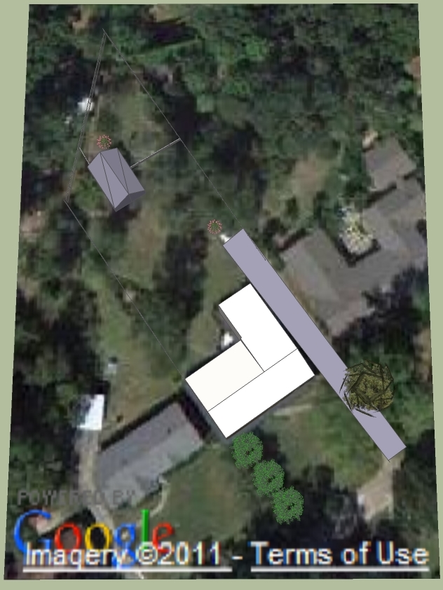 |
| Meadowood Ranch as seen in Google Earth plus SketchUp 3D model Rev01 |